Yoknapatawpha Revised
By Claire Thomas and Anonymous Allison from FM
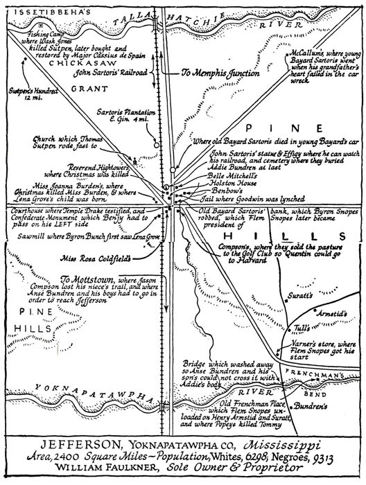
Yoknapatawpha County is a fictional area of Mississippi that William Faulkner invented to make as a setting for almost all of his texts. His original map that he created, however, does not have the locations of all the events in As I Lay Dying. Also, most of the places that are on the map seem to be incorrect. Allison and I decided to revise it.
We assumed that the location of the Bundren house was correct on this map. Slightly farther north along the road would be the sign to New Hope, where the Bundren's pass by. The Bundren's also pass by Samson's farm during his section of narration, although they do not stop for long. This would have to be positioned slightly North of New Hope.
Since they reach Tull's before the river, Tull's would have to be incorrect on the map. It should be placed along the road at the Southern part of the river, before the Bundren's cross. After they cross, they go to Armstid's farm to regroup and so Cash can heal his leg, so it would have to be North of the river near the intersection of the back road and the main road, not where it is placed on the map.
After this the Bundrens don't make many stops. They stop at Mottson, which is probably halfway down the main road. They also rest at Gillespie's and burn his barn somewhere along the main road, maybe about three quarters of the way along.
Works Cited
Faulkner, William. As I Lay Dying. New York: Vintage Books, 1930. Print.
Faulkner, William. Map of Yoknapatawpha. 1936. Web. 5 Dec. 2014.
